Radius Map — Draw a Radius Around Your Location
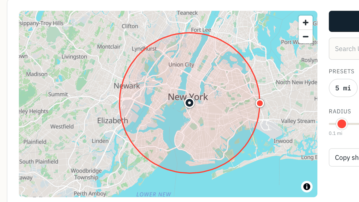
Pick a distance, get an instant area, circumference, and straight-line reach — from your location, a US city or ZIP, or wherever you click on the map.
All values computed live from area = π · r²; basemap is OpenStreetMap. Methodology and sources below.
Three ways to place the centre:
- Tap Use my location for where you are.
- Search a US city or ZIP in the box beside the map.
- Click anywhere on the map to drop the pin.
Then pick a radius from the presets, the slider, or by dragging the red handle on the ring.
Drag the dark centre pin to move the whole circle; drag the red handle on the ring to resize the radius. For exact distances, use the presets or slider; click any empty spot on the map to drop the centre there. Values update on release, so numbers stay steady while you drag.
Basemap © OpenStreetMap contributors — ODbL. See methodology.
Presets
- Radius
- 10 mi
- 16.1 km
- Area
- 314 sq mi
- 814 km²
- Circumference
- 62.8 mi
- 101 km
- Reach
- 10 mi
- edge-to-center, any direction
A radius map draws a distance circle so you can see what falls inside it — a job-search zone, a delivery area, or how far you can travel from a fixed point. For a 10-mile radius, that's 314 sq mi (813 km²) of ground and a 62.8 mi (101 km) boundary. Anywhere on that boundary is exactly 10 miles from centre, in a straight line.
What actually falls inside a radius
A radius on a map is a promise: anywhere I can reach without going further than N miles from this point. That's what makes it useful for real decisions — a 25-mile job-search radius is the pool of listings you'll actually consider; a 10-mile delivery zone is the ground your drivers cover before a time-slot promise becomes risky; a 5-mile apartment radius is the walk-and-transit envelope around a target address.
The number the tool draws doesn't change if you move the centre or rotate the map — it's a straight-line reach that treats "10 miles" as a physical envelope, not a driving route. A road-following alternative — a drive-time radius, or isochrone — bends the boundary to actual roads and speeds and is usually smaller than the straight-line reading suggests.
The four numbers your tool shows
Take a 10-mile radius as a worked example. Every number below comes from the same input — the radius you pick — via elementary geometry.
- Radius
- 10 mi
- 16.1 km
- Area
- 314 sq mi
- 814 km²
- Circumference
- 62.8 mi
- 101 km
- Reach
- 10 mi
- edge-to-center, any direction
Radius is the distance you picked. The slider goes from 0.1 mi (a block-sized circle, useful for micro-catchment or door-to-door planning) up to 250 mi (a multi-state view). Every reading shows both miles and kilometres.
Area is the ground surface inside the disc, computed π · r². A 10-mile radius covers 314 sq mi (813 km²) — that's the entire zone you're evaluating for a job search or a service area. Double the radius to 20 mi and the area jumps to 1,257 sq mi: 4×, not 2× (the square-law is spelled out below).
Circumference is the boundary length, 2 · π · r. For a 10-mile radius that's 62.8 mi (101 km) of edge. Useful when you're thinking "how long is the perimeter my delivery driver has to trace along the outside?" or sizing a geofence.
Reach is the straight-line distance from centre to any edge point — the same number as the radius, called out separately because most people mentally frame this as "how far can I get?" rather than "how big is my circle?". On a 10-mile radius, any point on the ring is exactly 10 miles from your pin, in every direction.
Radius sizes at a glance
Common radius choices and what they cover. Every number is computed from the same formulas the tool uses — no rounding tricks. Rows include every popular preset plus the medium-demand in-between sizes (15, 20, 30) our search data shows people actually pick.
| Radius | Area (mi²) | Area (km²) | Circumference (mi) | Circumference (km) | Reach |
|---|---|---|---|---|---|
| 1 mi (1.61 km) | 3.14 | 8.14 | 6.28 | 10.1 | 1 mi (1.61 km) |
| 5 mi (8.05 km) | 78.5 | 203 | 31.4 | 50.6 | 5 mi (8.05 km) |
| 10 mi (16.1 km) | 314 | 814 | 62.8 | 101 | 10 mi (16.1 km) |
| 15 mi (24.1 km) | 707 | 1,831 | 94.2 | 152 | 15 mi (24.1 km) |
| 20 mi (32.2 km) | 1,257 | 3,255 | 126 | 202 | 20 mi (32.2 km) |
| 25 mi (40.2 km) | 1,963 | 5,085 | 157 | 253 | 25 mi (40.2 km) |
| 30 mi (48.3 km) | 2,827 | 7,323 | 188 | 303 | 30 mi (48.3 km) |
| 50 mi (80.5 km) | 7,854 | 20,342 | 314 | 506 | 50 mi (80.5 km) |
| 100 mi (161 km) | 31,416 | 81,367 | 628 | 1,011 | 100 mi (161 km) |
Reach = the straight-line distance from the center point to any point on the edge, by definition equal to the radius. Values rounded for display; the tool computes to full precision.
The square-law: double the radius, quadruple the area.
Because area = π · r², the surface inside a circle grows with the square of the radius. Going 10 → 20 miles adds a lot more ground than the "×2" reading suggests: 4× more. Bumping a job-search radius from 20 to 30 miles opens up more than double the pool — 2,827 sq mi vs 1,257. Worth knowing before you dial the number in.
How people use a radius map
Job search — "within 25 miles of home"
Almost every job board takes a radius input. A radius map lets you see what that filter actually covers before you commit to the commute. A 25-mile radius encloses 1,963 sq mi (5,083 km²) — for most US metros that's the entire commutable region plus a suburb ring. Draw it, screenshot it, keep it next to the listings.
Delivery or service zones
Set a straight-line radius as the outer bound of where you'll serve, then verify each edge case on the map. A 10-mile delivery radius has 62.8 mi (101 km) of edge — useful when deciding whether a driver can realistically cover the boundary inside a promised time-slot.
Apartment hunting near a fixed point
You have one anchor — an office, a school, a partner's flat — and want to filter listings by distance from it. Rental filters usually use a straight-line radius; this tool shows exactly what the "5-mile radius" checkbox will include. Any point on the edge is that distance from the anchor.
"How far can I get?" planning
Weekend range, day trips, custody geo-fences, or any "how-far-in-every-direction" question collapses to a radius. The straight-line reach is a ceiling: real travel time is usually shorter because roads bend — a proper drive-time radius (an isochrone) would show a smaller, road-shaped envelope.
FAA / FMCSA 150-mile short-haul (US commercial drivers)
US commercial-driver hours-of-service rules include a short-haul exemption tied to a 150-air-mile radius from the normal work reporting location. The catch: it's specified in air miles, not statute miles — so the real ground envelope is bigger than the "150" suggests.
Drawing a radius on Google Maps and other tools
Google Maps' consumer app doesn't include a native radius-drawing control, so most searches for "google maps radius tool" end up on a third-party tool. The usual workarounds are Google My Maps (custom-shape overlay), a third-party layer like Mapfrappe, or a dedicated radius calculator like this one. If you're specifically looking for how to draw a radius on Google Maps, all three require more clicks than drawing it here — plus the ring you draw here is shareable via URL.
Radius map — frequently asked questions
How do I draw a radius on a map?
How big is a 10-mile radius?
What's the area of a 5-mile radius?
How do I map a radius around an address or ZIP code?
How is the area calculated?
Methodology & sources
- Computed metrics. area = π·r², circumference = 2·π·r, reach = r. Unit conversion: 1 mi = 1.609344 km. Derived from user input alone — no external dataset needed for the four outputs.
- Basemap. © OpenStreetMap contributors, used under the Open Database License (ODbL). Self-hosted vector tiles built from the Protomaps daily planet build; see /data-sources for the retrieval + rebuild details.
- US city / ZIP search. SimpleMaps US ZIPs v1.95.1 (~41,500 records; five fields per row — ZIP, city, state, lat, lng, population — the rest of the dataset's ~90 columns are dropped). Loaded lazily on first focus of the search box; no external API calls at runtime.
- 150-air-mile short-haul citation. Verified against FMCSA 49 CFR 395.1(e) via eCFR (retrieved Aug 2026): 150 air miles = 172.6 statute miles.
- Author. Marko Visic (MPharm, BSc Physics). See About.
- Data as of. (matches the registry's verified_date on the basemap-tiles domain). Content updated. .
- Not yet computed on this page. Population inside the radius and drive-time isochrones are absent — their primary sources (US Census / WorldPop; a self-hosted routing engine) are in the data-sources registry as candidate / GAP and won't ship until they're verified end-to-end. Approximating either without verified inputs would produce numbers this site doesn't stand behind, per the verified-or-omitted rule.